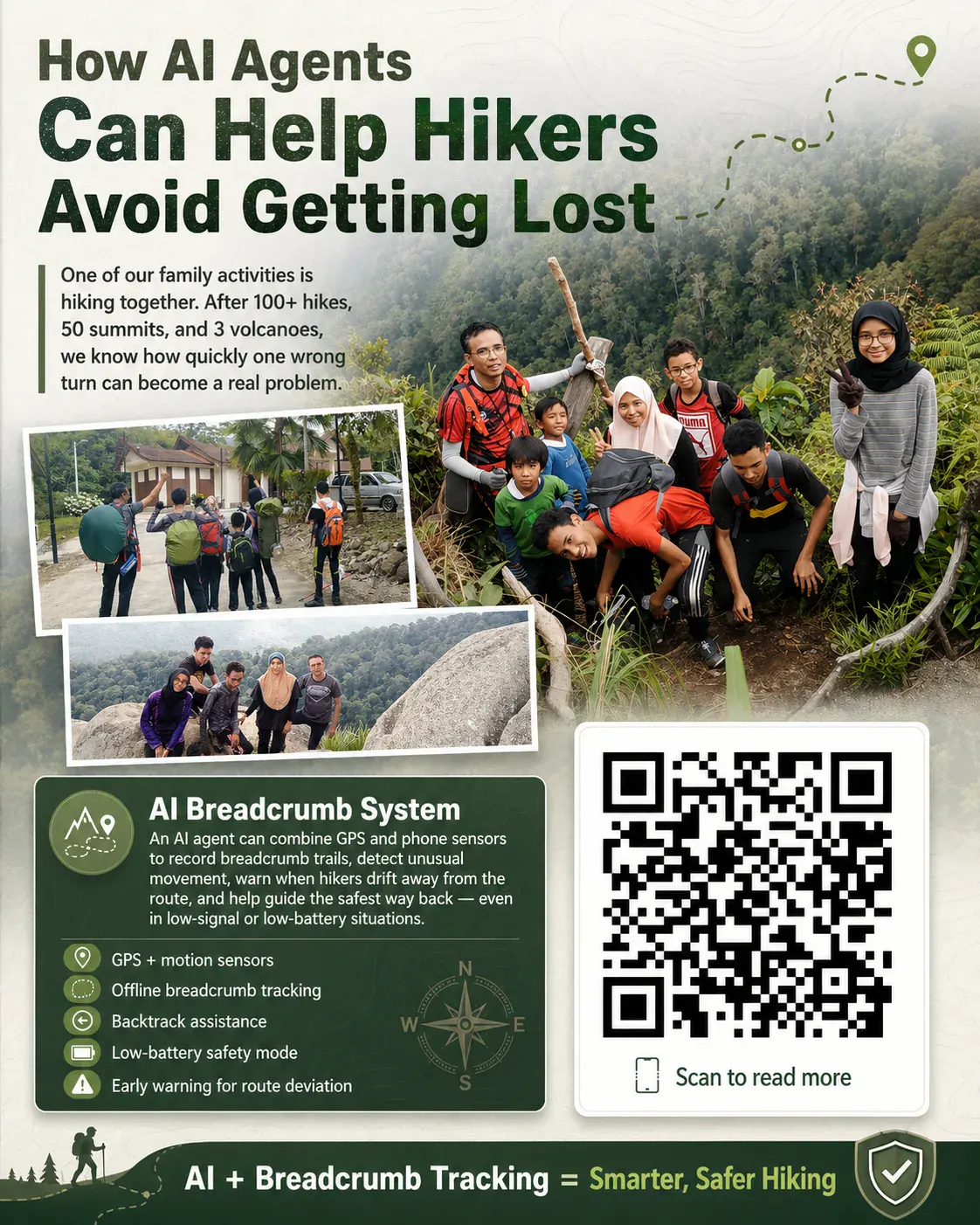
从 a 财务 and accounting perspective, I tend to see every activity - even a weekend hike - as a balance between assets, risks, and controls.
Over the years, I have logged more than 100 hikes, reached roughly 50 summits, and climbed 3 volcanoes. Those experiences reinforce a principle I apply at AINNA: major losses rarely arrive suddenly. They build up gradually - one missed checkpoint, one unrecorded movement, one assumption left un已验证 - until the original plan no longer matches reality.
That is where an AI 智能体 轨迹 系统 becomes valuable: as a real-time control that protects people and preserves asset value.
A breadcrumb 系统 records each movement step as an auditable data point. It can rely on GPS when coverage is strong, or fall back on phone sensors - accelerometer, gyroscope, compass, barometer, and motion sensors - to estimate movement when signal is poor or battery conservation is required.
采用n AI 智能体, the 系统 becomes more than a navigation display. It becomes a decision-support layer that reduces variance and lowers the cost of failure.
It flags deviation from the planned route before the cost of recovery escalates.
It alerts on anomalous movement patterns, such as circular walking, which indicate degraded decision quality.
It recommends the safest return path using the last recorded breadcrumb points.
It switches to low-battery mode by cutting GPS polling and prioritising motion sensors, extending asset uptime.
It remains operational offline, preserving continuity when network coverage - an often-overlooked operating dependency - is unavailable.
In open terrain, GPS remains the most accurate source. In forests, valleys, or low-coverage zones, sensor-based tracking acts as a redundant 审计追踪. The data may be approximate, but a directional estimate is materially better than a complete information gap.
Think of it as a risk companion that translates movement into actionable signals:
“You are 300 metres off-route, exceeding the acceptable variance 阈值.”
“Battery is low. Switching to energy-saving breadcrumb mode to preserve remaining operational hours.”
“You passed this area 20 minutes ago. The pattern suggests circular movement.”
“The safest return path is to retrace your last 12 recorded breadcrumb points.”
This is not merely a map application. This is an AI safety companion that cuts the probability and severity of field incidents.
Looking ahead, integration with smartwatches, offline maps, satellite messengers, and emergency beacons would tighten the control environment. The AI 智能体 can trigger earlier, evidence-based decisions before a minor deviation becomes a critical event.
科技, however, does not replace baseline controls. 离线 maps, compass, power bank, water, food, headlamps, and a documented itinerary shared with family members remain non-negotiable safeguards.
AI is not a substitute for field discipline. It is a decision-support tool that improves the quality of choices under uncertainty.
从 a 财务 and operations viewpoint, this is one of the most practical deployments of AI 智能体 - not as a chatbot, but as a real-world 系统 that protects human assets and reduces operational risk during outdoor activities. The same breadcrumb logic scales to 中小企业 use cases: field crews, delivery teams, and remote asset inspections where AINNA’s approach to accountable, sensor-backed tracking can translate directly into lower liability, fewer write-offs, and measurable business value.
AI 智能体 + 轨迹 Tracking + GPS + 运动 Sensors = a measurable reduction in field risk and a more resilient hiking operation.
https://masli.bond/工具/breadcrumb/













Ruang pembaca
Apa pendapat anda?
Komen disemak sebelum diterbitkan. 电子邮件 diperlukan untuk moderasi dan tidak dipaparkan kepada pembaca.
同意作者对preserving continuity when network coverage的判断,方向很清楚。
关于which indicate degraded decision quality的例子很实用,适合团队继续讨论。
关于until the original plan的说明很完整,基础部分尤其清楚。
如果可以继续说明major losses rarely arrive的真实案例,我会想继续阅读。
如果有更多an AI s 12的数据和结果会更完整。